Insert maps into documents
In most cases you want to insert maps you have found or created with geographic data into some document such as an article or report. Below is a step wise instruction with some examples.
The simplest and quickest way to get a map is to copy it from an Internet source (be aware of copyright). Do this by right-clicking on the image in your web browser and choose copy/copy image from the pop-up menu.
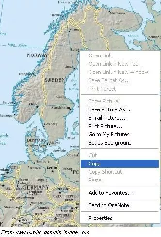
In a document (MS Word, OpenOffice, LibreOffice or alike), place the cursor at the proper location and insert the map by right-clicking again and choose Paste.
Saving a map from the web browser can be done by simply choosing Save Image/Picture from the pop-up menu when right-clicking, instead of Copy.
Once a map is in a document, its appearance can easily be edited by adding additional objects, like for example, text, arrows and lines.
Example 1: Retrieve a map of Skåne and inserting it in a document.
Example 2: Retrieve a map of Venezuela and inserting it in a document.
Image formats
Maps you find on Internet are mostly stored as static images.There are many different image file formats and some are briefly described below.
JPEG (Joint Photographic Experts Group)
JPEG is mostly used for photographs and pictures that have more than 256 colours and is probably the most wellknown since most digital cameras produce images in this format. JPEG actually a compression algorithm and works with 24-bit pictures. More information about JPEG.
PNG (Portable Network Graphics)
PNG has approximately the same functions as GIF, but does not include the same compression technique and can save up to 16 million colours. It is a lossless format meaning the compression does not decrease picture quality but the file size can be bigger than for other formats. It is best suited for storing line drawings, text, and iconic graphics. More information about PNG.
TIFF (Tagged Image File Format)
TIFF is a flexible format with eight or sexteen bits per colour. Different versions/types exist such as geotiff. More information about TIFF.
GIF (Graphic Image File Format)
GIF is the oldest picture format on the Internet. This format uses a compression algorithm (Lempel-Ziv-Welch) to reduce the file’s size by not saving all pixels. If many adjacent pixels have the save value (colour), only the first one will be saved through a method called “run-length encoding”. This format can only save pictures up to 8-bit pixels (256 colours). More information about GIF.
For more information about image (and other) file formats:
Library of Congress format descriptions